


Another stretch of winter weather is set to batter Saskatchewan once again, some areas worse than others. The snow has already started to fall in Humboldt and area and there’s more to come. East central Saskatchewan could see as much as 15-20 cm total accumulation during the work week, but that pales in comparison to what awaits the southeastern corner of the province where 30-50 cm may be in the offing.
It’s all courtesy of a Colorado low that’s moving across the American plains and is set to park for a few days in Minnesota. The trough that’s accompanying the storm centre will bring strong winds, colder than normal temperatures, and excessive snowfall to southern Manitoba and southeastern Saskatchewan.
“Certainly as far north as Humboldt will be affected,” says Natalie Hassel, warning preparedness meteorologist with Environment and Climate Change Canada. “Draw a larger radius around the southeastern corner of Saskatchewan, and you’ll find a lot of those areas in Saskatchewan will be affected by the storm, even if they don’t have a winter storm watch in effect.”
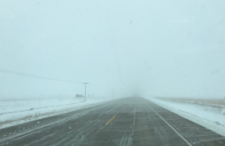
The impending storm will bring true blizzard conditions to the region, says Hassell, complete with heavy snowfall and driving winds that are expected to reduce visibility and choke area roadways with snow.
The storm is expected to begin in earnest on Tuesday with the main brunt being felt through the next few days as the front passes.
“Travel is expected to become increasingly difficult after the start on Tuesday and into Wednesday, continuing into Thursday. Both those days are going to be particularly bad, and then a slow improvement on Friday.”
Hasell suggests avoiding travel throughout the affected region if at all possible as the storm is expected to be long lasting compared to the recent blows we’ve seen.
“The extended period of blizzard conditions means that if you are on the highway, you could be stuck there.”
She says if travel is unavoidable, motorists need to have an emergency kit together, and for those closer to the southeast, it’s a good idea to have a several days stockpile of food, water, medications and other necessities, especially for rural residents. Guidelines for preparations of an emergency kit can be found at getprepared.gc.ca.
Again, the Humboldt area should see less snowfall, but winds are expected to gust to 40 km and higher starting as early as Tuesday. Depending on the snowfall amount in local areas, there could be issues with reduced visibility in blowing snow.
Conditions should begin to improve on Friday, followed by cooler than normal temperatures. This means the daily freeze/thaw cycle will be back, and depending on snow accumulation and wind, it could cause icing issues on highways once again. Temperatures are not expected to rebound until well into next week.


 Fri, Apr 19, 7:30 PM
 Full-time, Hourly, Labour


