


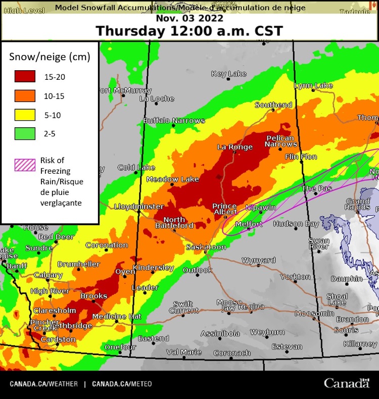
Time for round two for the opening to a Saskatchewan winter, says Environment and Climate Change Canada. This round will likely skirt the Humboldt and Saskatoon areas, says ECCC meteorologist Jesse Wagar. The bulk of the snowfall, expected on Wednesday and Thursday, will track in a line from Kindersley, through the Battlefords and Prince Albert, and points as far north as Buffalo Narrows and Southend. Humboldt will be on the fringe.
“We do have some messy weather moving into Saskatchewan today (Tuesday), “explains Wagar. “There may be a bit of a rain-snow mix at first, and unfortunately, there is a risk of seeing some freezing rain overnight tonight.”
Since Humboldt and points south are predicted to be right on the edge of the system, most of the heavy snow should stay to the north, but those in the northern parts of the listening area could be in for a considerable accumulation. Anyone travelling north should be prepared for conditions to be worse than what are presented in Humboldt. Humboldt could see around 2-8 cm of snow, but areas north should see in the range of 10-20 cm.
“Temperatures look to be hovering around the zero mark,” Wagar says. “The real cold will start to show up through the weekend.”
The system is tracking to the northeast, and the first precipitation should show up late Tuesday afternoon and into the overnight. The system will pack a one-two punch with a second round of precipitation coming in on Wednesday.
The good news for those battered by last week's storms down south is that there won’t be much of an event south of the Highway 16 corridor. While there is a risk of rain or freezing rain along the stretch, no significant snow accumulation is expected.


 Thu, Apr 25, 9:00 AM
 Agriculture, Transport, Full-time, Seasonal


